The Dâmbovița River, from a Source of Disease to Urban Splendour: How the River That Periodically Flooded Bucharest Was Channelled, and What Plans Exist for Its Banks
By Eddie Țone
- Articles
- 20 JUL 26
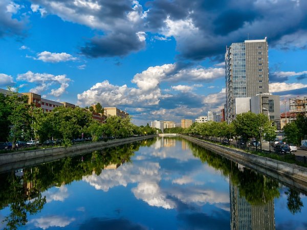
The Dâmbovița crosses Bucharest with the disciplined air of a civil servant who has memorised his route. It enters from the west, passes neighbourhoods, universities, ministries and apartment blocks, then leaves the city towards the south-east, confined between concrete slabs and boulevards where traffic behaves as though the river were illegally occupying valuable land.
Seen from Izvor Bridge or the United Nations Square, the water looks well-behaved. Its history tells a very different story. For centuries, the Dâmbovița was a source of drinking water, a power supply for mills, a rubbish dump, an urban obstacle and a hydrological threat. Bucharest residents drank from it, washed in it, threw waste into it and then wondered, with remarkable administrative consistency, why the water smelled terrible and brought trouble.
Transforming the river into a controlled channel took nearly two centuries of projects, delays, floods and engineering interventions. Now, after the city has managed to tame it almost to the point of rigidity, architects and urban activists are trying to bring it back to life. The story of the Dâmbovița therefore acquires a splendid irony: first Bucharest defended itself from the river, and today it is trying to find its way back to it.
The Old Dâmbovița: Water for Drinking, Washing and Disposing of Whatever Was Left Over
Before modern water pipes, the Dâmbovița and the city’s wells were Bucharest’s main sources of water. It was loaded into water carts and sold by water carriers, who descended to designated fords at places such as Sfântul Ionică, Saint Anthony Square and Jignița. Wealthier residents could afford water brought from Herăstrău, which was considered cleaner and, naturally, cost more. Hygiene had differentiated pricing even then.
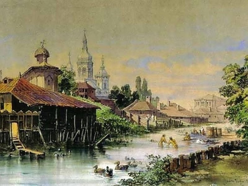
Photo: Dâmbovița in 1868. Aquarel by Amedeo Preziozi
At the same time, the river received wastewater, household refuse and rubbish. Ponds and marshy ground formed around it, while mills and buildings erected too close to the banks slowed the current. The city had only rudimentary sanitation infrastructure, so the combination of drinking water and urban waste offered bacteria excellent accommodation, complete with a view of the city centre.
By the end of the 19th century, analyses and debates concerning the capital’s water supply revealed just how fragile the system was. The filters at Bâcu–Arcuda struggled to operate effectively, the filtered water could remain laden with bacteria, and its temperature reached approximately 26°C in summer. A lasting solution arrived with the use of alternative sources and the development of modern water-supply and sewerage networks.
Mills, Filth and a River That Made Its Own Way Through the City
The Dâmbovița followed a winding course, with bends, secondary branches and low banks. The mills installed along the river used the power of the water, but their weirs raised the river level and encouraged flooding. Buildings constructed beside the water narrowed the channel even further. When heavy rain arrived, the river reclaimed its floodplain using methods of its own—highly effective methods that were also rather expensive for property owners.
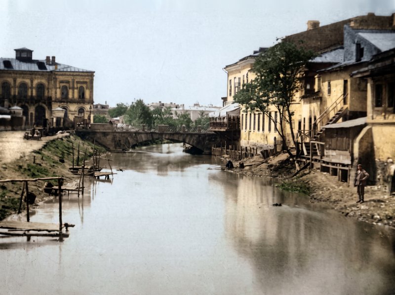
Photo: The Dâmbovița River in 1860. Photograph by Carol Popp de Szathmari / Image restored and colourised using artificial intelligence, while largely preserving the original details.
As early as the first decades of the 19th century, the authorities tried to clean the riverbed and clear the banks. In 1815, Prince Ioan Gheorghe Caragea requested the construction of a dredger inspired by a machine he had seen in Constantinople. Bucharest craftsmen were summoned to build it, but no technical description was available. The project remained an intention, a situation that sounds surprisingly contemporary. During the same period, the physician Ioan Serafin proposed the construction of embankments along the Dâmbovița.
The Organic Regulation provided for canals that would carry water from the city’s lakes and marshes towards the river. In 1830, Grigore Băleanu even submitted a project to transform the Dâmbovița into a navigable river. Bucharest was already dreaming of boats and waterborne commerce while the banks periodically collapsed and the riverbed collected the city’s waste. Urban ambition has always enjoyed a comfortable lead over infrastructure.
The Floods That Forced Bucharest to Take the River Seriously
Major floods were recorded in 1779, 1834 and 1851. The flood of 1839 affected approximately one third of the city and triggered a new series of projects. Petrache Poenaru, known for his work as an educator and inventor, proposed strengthening the banks, installing weirs and constructing a canal through Bucharest. The mills were to be adapted so that each had only one wheel, reducing the obstacles in the path of the water.
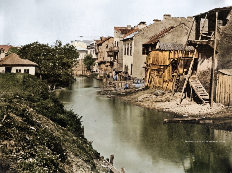
Photo: The Dâmbovița River in 1855. Photo credit: Ludwig Angerer / Image restored and colourised using artificial intelligence, while largely preserving the original details.
The most serious episodes came in 1840, 1864 and 1865. The flood of 1865 kept the Izvor, Belvedere, Sf. Apostoli and Radu-Vodă districts under water for approximately two weeks. Cișmigiu and its surroundings were transformed into an expanse of water from which only tree trunks remained visible. This was a Bucharest where travelling through the city centre could suddenly take on a distinctly nautical character.
The disaster accelerated discussions about regulating the river. The authorities understood that simply cleaning the riverbed and issuing orders to residents produced modest results. The river required a coherent intervention based on raising and reinforcing the banks, widening and deepening the channel, eliminating dangerous bends and reorganising the city’s sewerage system.
Grigore Cerchez and the Great Regulation Works of the 1880s
The decisive plan was drawn up in 1877 by engineer Grigore Cerchez, who became Bucharest’s chief engineer after studying in Paris. The major regulation works began in 1880 and continued during the first part of the decade. The river’s course was straightened, its meanders were cut off, its bed was deepened and its banks were developed to increase its water-discharge capacity.
The intervention radically changed central Bucharest. The river of fords, islands, mills and irregular bends became a controlled urban watercourse. The surrounding marshland could be drained, while the new embankments created traffic arteries. Bucharest thus acquired an essential element of its modernisation, alongside paved streets, public lighting and a municipal water supply.
The regulation of the Dâmbovița and the construction of the street sewerage system were two parts of the same sanitation programme. In 1890, City Hall organised tenders to extend the sewer network along several streets. Documents from the period record companies, cost estimates, price reductions and completion deadlines, proof that the administration had already discovered the eternal pleasures of public procurement.
The 1930s and the Dream of an Esplanade over the Dâmbovița
Following the regulation works of the 19th century, the Dâmbovița had become more predictable, but it still cut through the city centre along a corridor that the authorities regarded as inconvenient, unsanitary and insufficiently monumental. Interwar Bucharest aspired to broad boulevards, orderly squares and urban vistas with a Western European air. To some municipal officials, a visible river lined with embankments and crossed by bridges seemed like a remnant of a less polished version of the capital.
During the term of Dem. I. Dobrescu, Mayor General between 1929 and 1934, the idea emerged of covering the Dâmbovița in the central area and constructing a large esplanade above it. Dobrescu, nicknamed the “Pickaxe Mayor” because of the pace of his municipal works, viewed the city as an organism requiring decisive intervention. Streets had to be widened, squares reorganised, and the river was to descend discreetly beneath a surface intended for traffic and urban ceremonies.
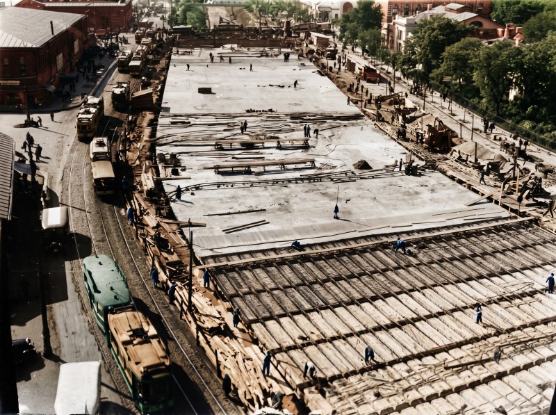
Photo: The concrete deck built during the interwar period. Photo credit: Bucharest Municipality Museum / Image restored and colourised using artificial intelligence, while largely preserving the original details.
Construction of the concrete deck in what is now Unirii Square began during the first half of the 1930s. Technical assessments and administrative documents identify 1934 as the year in which the original structure was built. Other historical sources trace the project through to 1935 or 1936, when the development of the square and esplanade reached the form presented to the public as one of the capital’s major municipal achievements.
The project begun under Dem. I. Dobrescu was continued by Mayor Alexandru G. Donescu. On 7 November 1936, the newspaper Viitorul praised the work, completed in less than three years, and presented it as a model of municipal administration. The triumphant tone belonged to an era in which every properly laid concrete slab could quickly acquire the status of a victory for civilisation.
In essence, the deck was an extremely wide reinforced-concrete bridge built above the riverbed. The structure carried the Dâmbovița beneath the square, from the area near Manuc’s Inn towards the point where the river re-emerges today beside the Unirea department store. Depending on the measurements and documentation consulted, its length is given as approximately 330 to 360 metres, while its width reaches around 32 metres.
The original ambition extended much further. Interwar municipal officials discussed an “Esplanade of the Dâmbovița” and the possibility of covering a considerable section of the river through central Bucharest. The deck in the Unirii area was intended to mark the beginning of a much broader transformation. The economic crisis, political changes and the war reduced the project to the section that was actually completed.
The square built above the river altered the relationship between Bucharest and the Dâmbovița. The water disappeared from the immediate landscape and was replaced by a vast urban surface and a new monumental perspective. The city gained land without diverting the river, an elegant feat of engineering, provided nobody went below to inspect the seepage.
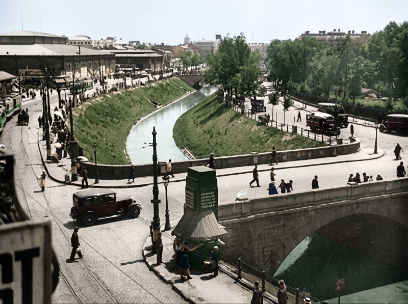
Photo: Year 1941. / Image restored and colorized using artificial intelligence, preserving the original details.
By the 1940s, the interwar project had largely been completed, while the idea of covering the Dâmbovița in its entirety remained on paper. The deck continued to function, undergoing subsequent repairs and alterations, and was later incorporated into the massive transformations of Unirii Square carried out during the communist period.
The Dâmbovița in the 1960s: An Old, Tired River Still Close to the Street
During the 1960s, the Dâmbovița largely retained the appearance it had acquired following the regulation works begun in the 19th century and continued during the interwar period. Its channel crossed the city between stone embankments and retaining walls, with relatively low bridges and riverside roads running close to the water. Compared with today’s landscape, the river looked narrower, less monumental and more naturally integrated into the urban fabric. Bucharest residents could observe it from close range and, in certain places, descend towards the water by means of steps or sloping banks.
Photographs from the period show a calm watercourse, with vegetation growing along its edges and water levels that were often low. In some places, the Dâmbovița resembled a provincial canal threading its way through a capital in the midst of rapid industrialisation. Trams travelled alongside it, as did a small number of cars by current standards, while pedestrians used its bridges as natural extensions of the streets.
The water, however, carried the burden of a city expanding at a dizzying pace. The sewerage network developed more slowly than the built-up areas, and wastewater reached the river either directly or indirectly. In practice, its urban course also functioned as a receptacle for household and industrial waste. The relatively calm appearance of the surface concealed heavily degraded water, with a powerful smell during warm periods and deposits accumulating on the riverbed. The Dâmbovița thus possessed the slightly melancholy elegance of an urban object used intensively and maintained as circumstances allowed.
The neighbourhoods along the banks still retained a human scale. In the Izvor area, houses descended towards the water, while old streets reached almost as far as the embankments. At Grozăvești, Cotroceni and Ciurel, the river passed through a more open landscape of houses, small industrial facilities, vacant plots and gardens. Towards Timpuri Noi and Vitan, the Bucharest of factories emerged, with industrial halls and chimneys rising near the water. The river therefore connected several cities within a single one: the administrative centre, the old district left between apartment blocks and the capital’s industrial belt.
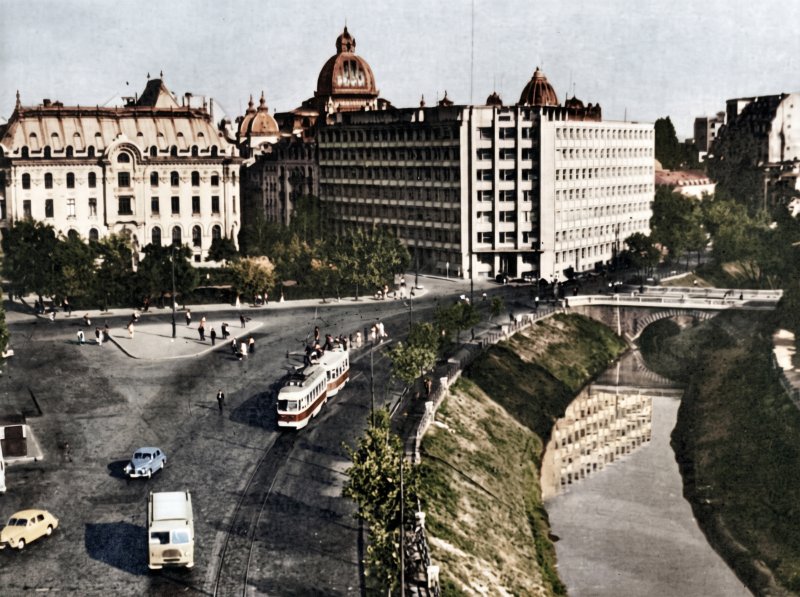
Photo: The Dâmbovița Embankment, 1968. Photo credit: George Șerban / Image restored and colourised using artificial intelligence, while largely preserving the original details.
The Dâmbovița of the 1960s offered few reasons for a leisurely riverside walk. Its banks served traffic and municipal works, while the water inspired resignation rather than enthusiasm. Bucharest residents crossed it every day and went about their business. It was their river, but the relationship resembled that of two old neighbours who greet each other with a nod and avoid lengthy conversations.
The 1970s: Paper Boats, Rats and the First Signs of the Great Construction Site
During the following decade, the deterioration became difficult to ignore. Photographer Andrei Bîrsan, who grew up near the Dâmbovița, recalled descending to the river with his father in the Izvor area. They made little boats out of newspapers and set them loose on the water. The river was extremely dirty, and rats swarmed between its banks. To a child, the paper boats were setting off on a Jules Verne-style adventure; to an adult, the setting offered a fairly clear lesson about the capital’s standards of urban hygiene.
The image is worth remembering because it perfectly captures the ambiguity of the Dâmbovița in the 1970s. The river remained accessible. People could descend towards it, touch it and use it as an improvised playground. That closeness, however, came bundled with filth, smells and a category of urban wildlife rarely featured on tourist postcards.
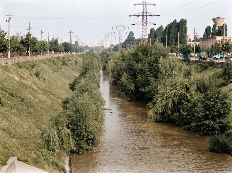
Photo: The Dâmbovița River in the 1970s, in the Semănătoarea area. Photo credit: Gjon Mili, LIFE / Image restored and colourised using artificial intelligence, while largely preserving the original details.
Romania had endured the catastrophic floods of 1970, followed by another devastating episode in the summer of 1975. Bucharest was spared the scale of destruction seen in other regions, but the floods drew the authorities’ attention back to the vulnerability of the river basins in the south of the country and to the need for an integrated development of the Argeș and Dâmbovița rivers. Technical documents concerning the future Bucharest–Danube Canal explicitly connect the revival of hydrotechnical projects with the floods of the 1970–1980 decade.
During the same period, the river came into direct contact with another enormous project: the Bucharest Metro. Its first line, inaugurated on 19 November 1979 between Semănătoarea and Timpuri Noi, largely followed the Dâmbovița corridor. The choice of route made both engineering and urban-planning sense, as the river valley provided a continuous direction through the city. The works, however, altered the groundwater regime and complicated the relationship between the riverbed, the sewerage system and the underground infrastructure. These effects would weigh heavily on the design of the river-development project during the following decade.
By the late 1970s, the Dâmbovița landscape combined the old embankments with construction equipment. Temporary bridges, pipes, machinery and fences appeared wherever the metro or new traffic arteries were being built. A photograph from January 1979 preserves the sight of a tram crossing the Dâmbovița on the temporary bridge at Grozăvești, a scene possessing all the technical charm of the period: public transport, sheet metal, steel beams and five-year-plan optimism.
The river still retained its old channel. The water flowed at a low level between ageing walls, with grassy sections and areas where the mud became visible. In the centre, the section between Unirii Square and the present-day United Nations Square remained covered by the concrete deck constructed in the 1930s. Traffic and urban facilities occupied the surface above it, while the Dâmbovița passed beneath the city like an oversized pipe hidden under the square.
Seen in photographs from the decade, the Dâmbovița of the 1970s appears surprisingly modest. It lacked today’s broad expanse of water, hydrotechnical thresholds and the severe symmetry of the concrete banks. It was a narrow, dirty and familiar watercourse, with an intimacy that the later development would sacrifice in exchange for control.
The First Half of the 1980s: The Old River Beside a City That Was Beginning to Disappear
At the beginning of the 1980s, the Dâmbovița still looked similar to the river of the previous decade. Photographs taken by Andrei Bîrsan around Eroilor Bridge, including some from 1985, show the old channel with little water, irregular edges and embankments far removed from their current geometry. Around the river, however, one of the most violent urban transformations in Bucharest’s history was under way.
The Izvor neighbourhood, located on the right bank, was demolished to make way for the House of the Republic and the new political and administrative centre. Streets, houses, gardens and churches disappeared, while the river remained for a time on the edge of an enormous void filled with dust, cranes and lorries. The old Dâmbovița thus flowed beside a city being dismantled piece by piece. Images of it from 1983 or 1984 possess a particular sadness: the water was the same, but the neighbourhoods that had given it scale and context were vanishing beneath the blades of bulldozers.
The transformation of the river was connected with the redevelopment of the city centre, the construction of the metro, the reconstruction of the sewerage system and plans for navigation along the Bucharest–Danube route. The communist leadership sought to create a monumental urban axis, control flooding and separate clean water from wastewater. The Dâmbovița was to acquire a constant flow and an orderly appearance suited to the new ceremonial capital.
1985–1988: The Dâmbovița Becomes a Construction Site and Acquires Its Present Form
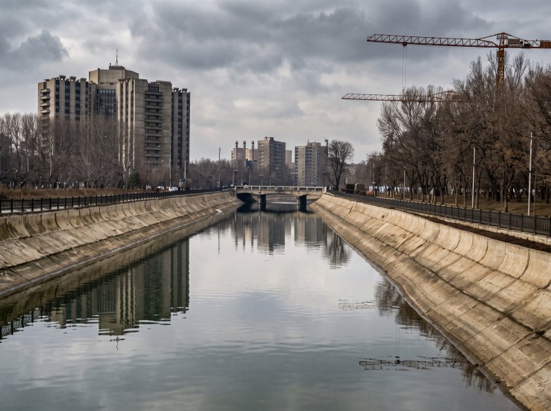
Photo: Dâmbovița in the 80s. / Credit: Agerpres / / Image restored and colorized using artificial intelligence, preserving the original details.
The major phase of the “Integrated Development of the Dâmbovița River” took place between 1985 and 1988. The works completely transformed the appearance of the urban watercourse. The old channel was excavated, widened and replaced with an artificial concrete basin divided into sectors controlled by hydrotechnical nodes. The water visible at the surface was to be maintained at predetermined levels through thresholds and sluice gates.
Beneath this basin, the Wastewater Conduit was installed, a vast collector designed to carry sewage by gravity towards the Glina treatment plant. In practical terms, the solution created a two-level Dâmbovița. The river water flows above, while below it lies an enormous underground infrastructure, hidden from view and generally noticed only when it causes problems.
During the works, the riverbed became a vast trench. Construction photographs show excavators positioned on the bottom of the river, alongside cranes, formwork, reinforcing steel and workers erecting the walls of the new basin. The watercourse was temporarily diverted through pipes or service channels. The riverside roads became corridors for machinery, while crossing the centre took on the character of an expedition through fences and temporary footbridges.
The interwar concrete deck covering the river between Unirii Square and United Nations Square was removed. The Dâmbovița returned to the surface along the section beside the Palace of Justice, while most of the bridges were rebuilt. The operation produced one of the urban-planning paradoxes of the period: the regime that demolished entire neighbourhoods restored to the city a section of river that had been hidden for approximately half a century.
Upstream, between 1985 and 1988, the Lacul Morii reservoir was constructed to regulate water flow and increase the capital’s flood-protection capacity. The Ciurel Dam and the lake completely transformed the landscape of western Bucharest. The area of houses, gardens and plots of land near the old river course became a vast expanse of water. The project formed part of a hydrotechnical system comprising the reservoir, the urban basin, regulation nodes and flood-discharge works.
The works also encountered dramatic episodes. The underground infrastructure at Unirii Square had become extremely complex, with the river, the sewer conduit, the metro tunnels and the road underpass situated at similar levels. In May 1987, damage caused during construction allowed water to enter the Unirii metro stations and the tunnel towards Timpuri Noi. The incident demonstrated just how sensitive the mechanism hidden beneath the city centre had become.
By the completion of the works, the Dâmbovița already resembled the river of today. The water occupied a much wider channel, with sloping concrete walls and a controlled level. The old points of access to the banks disappeared in many places, while the direct relationship between people and water was replaced by parapets, roadways and substantial differences in elevation. The river became cleaner at the surface, safer and infinitely more photogenic when viewed from a distance.
Bucharest had therefore solved one hydrotechnical problem and created another, this time of an urban nature. The Dâmbovița of the 1970s could be touched, although doing so required serious sanitary precautions. The Dâmbovița built during the 1980s offered control, monumentality and protection, but resembled an exhibit placed inside a very long glass case. The city could see it more clearly, yet found it more difficult to reach.
Keeping the River Safe Remains an Ongoing Project
The control achieved during the 1980s requires continuous maintenance. Flood-risk management plans include works to secure the Lacul Morii Dam, modernise its installations, limit seepage, maintain hydromechanical equipment and reinforce the developments between the reservoir and the Tânganu node. The plans also provide for hydrological studies, the modernisation of the Dragomirești node and the construction of the non-permanent Arcuda reservoir, with a projected capacity of 16.25 million cubic metres.
Official documents treat the integrated development of the Dâmbovița as a major project for protecting Bucharest. Urban splendour therefore depends on a discreet army of sluice gates, collectors, dams and installations. An elegant promenade works beautifully when the mechanisms beneath it perform their duties with exemplary dullness.
Dâmbovița Apă Dulce and the Attempt to Bring the City Back to the River
In recent years, the discussion has shifted from simply defending the city against the water towards reconnecting the city with it. The Dâmbovița Apă Dulce programme, developed by Nod Makerspace and the Ivan Patzaichin – Mila 23 Association, proposes transforming the river into a green-blue corridor, with public access to the water, riverside vegetation, recreational spaces and cultural activities. The programme’s vision uses 2035 as a target for integrating the river into the city’s climate resilience and community life.
The first interventions take the form of “urban acupuncture”. The landing stages at the Opera, United Nations Square and Timpuri Noi allow people to approach the water physically and provide facilities for canoeing and kayaking. At Timpuri Noi, a project funded in 2025 with 256,500 lei aims to transform an abandoned space into an accessible public area, with cooling points, sustainable lighting and events dedicated to climate issues and urban culture.
In May 2026, the Open Streets programme included free outings on the Dâmbovița and a debate about the river’s future. The Dâmbovița 2035 exhibition presented proposals resulting from an international competition of ideas for six sections of the river, along with directions for a future master plan. This is where the essential distinction lies: Bucharest currently has pilot interventions and a vision that is still being developed, while a complete transformation of the riverbanks will require administrative coordination, technical design and long-term funding.
What a Truly Urban Dâmbovița Might Look Like
Any realistic revitalisation must begin with the river’s hydrotechnical character. Its concrete walls, underground conduit, regulation nodes and flood-protection role limit more romantic solutions. The Dâmbovița could nevertheless become a linear park through terraces built closer to the water, landing stages, pedestrian routes, cycle lanes, vegetation adapted to each section and a reduction in the dominance of cars along certain stretches.
Renaturalisation could be gradual and vary from one area to another. The central section requires solutions compatible with its heritage and dense infrastructure. Timpuri Noi and the former slaughterhouse area offer more generous spaces for vegetation and community facilities. Lacul Morii could function as a recreational destination connected to the river, while pedestrian links could transform the Dâmbovița into a continuous urban axis.
After two centuries of fear, sewerage works and concrete, Bucharest appears ready to regard the river as a public space. The road ahead remains long, because cities repair their relationships with water more slowly than they install kerbstones. The first landing stages, the Dâmbovița 2035 competition and the events organised along the riverbanks nevertheless indicate a change in perspective.
The Dâmbovița was once drinking water, a drainage channel and a force capable of occupying entire neighbourhoods. It later became an engineering structure largely hidden from view. The next stage could transform technical safety into urban beauty and turn the riverbanks into a place where Bucharest can finally allow itself a few moments of rest.
You may also like: Bucharest’s lakes: 20 aquatic landmarks with stories