Bucharest’s lakes: 20 aquatic landmarks with stories
By Eddie
- Articles
- 15 JUN 26
At first glance, Bucharest seems like a city with a rather administrative relationship with water. The Dâmbovița flows obediently between concrete banks, the Colentina hides under bridges and between neighborhoods, while the lakes appear on the map as blue patches that somehow escaped the city’s obsession with curbs. And yet, the city has a surprisingly rich aquatic geography, with lakes born from tamed rivers, former ponds turned into parks, hydrotechnical reservoirs, and wetlands that emerged where an urban project remained suspended somewhere between ambition and abandonment.
The 20 Bucharest lakes discussed below tell, together, a story with several layers. Some have the air of an elegant promenade, as in Herăstrău, Cișmigiu, or Titan. Others have a technical biography, such as Lacul Morii, created in connection with the development of the Dâmbovița and the city’s protection against floods. The lakes on the Colentina form a chain arranged along the course of a lowland river that, for a long time, caused floods, marshland, and plenty of administrative headaches. Văcărești remains the spectacular case of nature occupying an abandoned hydrotechnical development and transforming it into an urban wetland with natural park status.
Water quality must be treated with caution. Bucharest is a large urban agglomeration, with an industrial history, dense neighborhoods, stormwater runoff, sediments, waste, and permanent pressure on its banks. The waters sometimes look good in photographs, especially at sunset, when any water surface suddenly becomes poetic. Environmental analyses, however, require a more sober reading. In the absence of updated public reports for each lake, statements about water quality should be understood as contextual observations. But let us take them one by one.
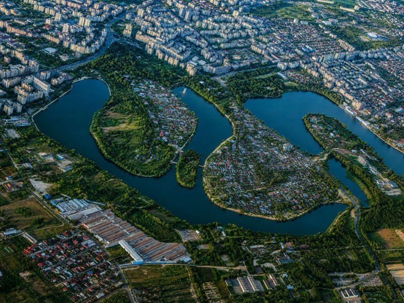
The Colentina chain, the blue spine of northern and eastern Bucharest
The Colentina is Bucharest’s great discreet river. Unlike the Dâmbovița, which has a boulevard, embankments, and a central presence, the Colentina works more quietly, through a system of lakes that, within Bucharest, stretches from Străulești toward Pantelimon. Before modern development works, its meadow was low, meandering, prone to flooding, and full of small raised garden plots. The works carried out in the 20th century transformed this territory into a succession of reservoirs with hydrotechnical, urban, and landscape roles.
Lake Străulești
Lake Străulești opens Bucharest’s Colentina chain from the northwest. It is a lake on the urban edge, where the city still seems to negotiate with Ilfov, among fences, vegetation, low houses, and fragments of semi-rural landscape. In the past, the area belonged to a gentler geography, with meadowland, low banks, and water making its way without hurry.
From the perspective of water quality, Străulești should be seen as part of the Colentina system, with predictable urban pressures: sediments, aquatic vegetation, waste, upstream inputs, and interventions along the banks. It has potential for walking routes and urban ecology, but it needs better protected banks and a more coherent relationship between properties, public space, and water.
Lake Grivița
Lake Grivița continues the Colentina’s route through an area where Bucharest mixes housing, infrastructure, and landscape. It is less famous than Herăstrău, but important for the hydrological logic of the north. Its banks clearly show one of the city’s major problems: access to water exists on the map, then becomes complicated on the ground.
Grivița has the biography of an urban reservoir. Its water quality depends on circulation within the system, organic load, the condition of the banks, and maintenance works. For Bucharest, it could function as a neighborhood space, rather than as a simple backdrop glimpsed through fences.
Lake Băneasa
Lake Băneasa has a privileged position, close to the forest, residential neighborhoods, the northern area, and the routes toward the airport. Its name carries an old resonance, with hints of estate, forest, villas, and roads leading out of the city. The water adds a note of calm to the area, even though Bucharest manages, with perseverance, to turn even calm into a real-estate resource.
As part of the Colentina chain, Băneasa has systemic vulnerabilities. The water must be assessed through quality indicators, the condition of sediments, urban pressure, and upstream inputs. The landscape has value, and the bank vegetation gives it an ecological role worth protecting.
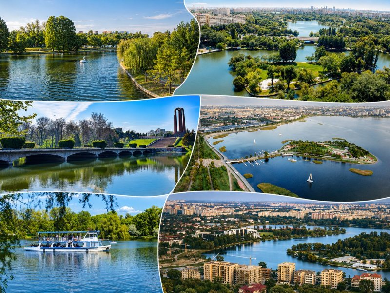
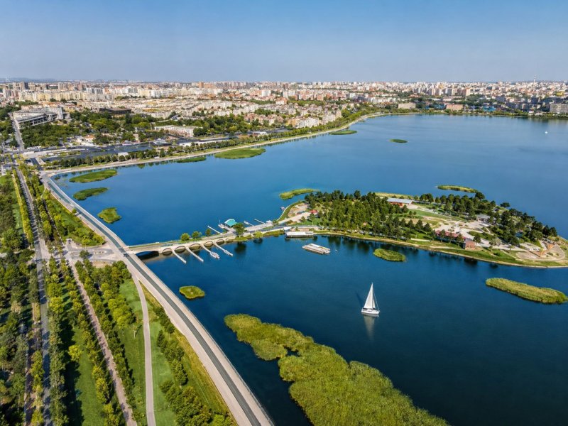
Lake Herăstrău
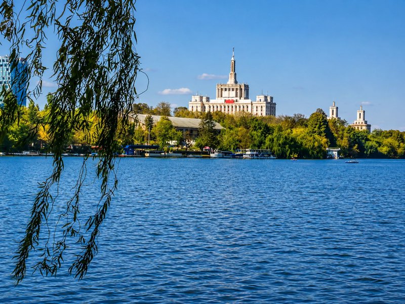
Herăstrău, today the lake in King Michael I Park, is Bucharest’s great representative lake. The old Herăstrău Park was established in 1938 and inaugurated by King Carol II, while later extensions consolidated the area as one of the city’s major social stages. Here, water has almost every possible function: scenery, leisure, boat route, photo backdrop, restaurant neighbor, and mirror in which Bucharest occasionally checks its European posture.
Water quality remains a sensitive issue. A lake so heavily used accumulates pressure from many directions: traffic, terraces, birds fed improperly, aquatic vegetation, waste, and seasonal fluctuations. Herăstrău has charm, but also fatigue. It is probably the most visible patient of the Colentina system, which entered a well-deserved period of redevelopment in 2026.
Lake Floreasca
Lake Floreasca has the elegance of an expensive neighborhood, with water, villas, restaurants, and flashes of northern urbanism. Here, the Colentina passes through a Bucharest that has massively changed its social status in recent decades. The lake has become part of a landscape of urban consumption, where the view sometimes becomes more important than public access.
The water of Lake Floreasca remains tied to the entire Colentina system. Its quality depends on water circulation, sediments, vegetation, and diffuse pressures. For an intelligent city, Floreasca should be treated as blue-green infrastructure, with accessible banks, quiet areas, and rigorous maintenance.
Lake Tei
Lake Tei has one of the strongest neighborhood identities among Bucharest’s lakes. Its name has passed into streets, institutions, local stories, and orientation landmarks. Between Tei, Plumbuita, Pipera, and Andronache, the water preserves the memory of a territory where the river once drew a more capricious relief.
Water quality must be read through the same lens of the urban Colentina. The lake receives upstream influences and pressures from its own banks. Where bank vegetation survives, the place has ecological value. Where the bank is suffocated, the lake becomes a beautiful photograph with a complicated basement.
Lake Plumbuita
Lake Plumbuita has a rare advantage: next to it stands Plumbuita Monastery, an important historical landmark of Bucharest. The water, the church, the park, and the neighborhood create an urban combination full of contrast. On one side there is the quiet of the old monastic settlement; on the other, the dense, pragmatic city, always ready to park almost up to the reeds.
The lake has ecological and landscape potential, but its water quality depends on the condition of the entire Colentina and on local maintenance. Plumbuita could be a valuable place for urban education about water, heritage, and nature. It has the scenery, it has the story; what it still needs is administrative consistency.
Lake Colentina
Lake Colentina, as a distinct name in the urban inventory, must be treated carefully, because the name can easily be confused with the Colentina River itself. Strictly speaking, it is a lacustrine sector in the eastern part of the city, connected to the reservoir system on the Colentina, and less present in tourist conversation than Herăstrău, Floreasca, or Tei.
Its water quality reflects the normal pressures of an urban reservoir. Colentina, in this area, needs monitoring, cleaning, waste control, and bank protection. The lake has value especially as a piece of a system, and Bucharest still treats systems too often as mere technical details.
Lake Fundeni
Lake Fundeni lies in a dense eastern area, associated with neighborhoods, hospitals, busy roads, and fragments of vegetation. The name Fundeni preserves the memory of the old raised garden plots formed in the Colentina meadow, while today’s lake is the result of works that transformed the river into a succession of reservoirs.
The water at Fundeni has a typical situation for urban lakes: ecological value, multiple pressures, variable appearance, and a major need for maintenance. The place could become a much stronger neighborhood resource, especially through pedestrian routes, birdwatching, and constant cleaning of the banks.
Lake Dobroești
Lake Dobroești marks the transition toward the eastern contact area between Bucharest and Ilfov. It is a lake on the administrative edge, and places like this often suffer from an old problem: when responsibility is shared between several institutions, the water patiently waits for people to finish clarifying who was supposed to take the first step.
Dobroești has hydrological and landscape value, being part of the downstream section of the Colentina. Water quality depends on everything that happens upstream, but also on local pressures. For the urban reader, the lake deserves to be seen as part of greater Bucharest, that real city which crosses administrative borders with a natural ease that administration finds harder to achieve.
Lake Pantelimon
Lake Pantelimon is one of the large reservoirs of the east. In hydrological inventories, it appears in relation to Pantelimon I and Pantelimon II, while in everyday use the public often perceives it under the generic name Lake Pantelimon. It has a broad opening and the air of an edge where the city prepares to become something else.
Water quality, as with the other lakes on the Colentina, is linked to the entire chain. Sediments, nutrients, aquatic vegetation, and human pressure matter as much as the beauty of the water surface. Pantelimon has potential for leisure and nature, but it requires a shared vision between the capital and neighboring localities.
Lake Morii and the engineered Dâmbovița: engineering, concrete, and urban memory
The Dâmbovița is Bucharest’s official river, the one that crosses the center, passes by institutions, campuses, bridges, and neighborhoods, then continues onward with all the city’s stories in its riverbed. Its modern development aimed to control floods and integrate the river into a broad hydrotechnical system. Lake Morii belongs to this family, and the engineered Dâmbovița in the western part of the city should also be read in relation to it.
Lake Morii is the largest urban body of water associated with Bucharest. It was created on the Dâmbovița, in the west of the city, with a hydrotechnical role, including flow control and flood protection. It has a dam, an island, a wide expanse, and an almost marine atmosphere on windy days, when the neighborhood gains, for a few minutes, the air of an inland port.
The story of Lake Morii also has a painful side. The development radically changed the Giulești–Crângași area, and part of the old urban-edge fabric disappeared in the process of hydrotechnical transformation. Today, the lake is being claimed by promenade, sports, events, and public-space projects. Water quality must be viewed through the regime of the Dâmbovița, urban inputs, and maintenance works.
Otherwise, instead of a separate discussion about “Lake Dâmbovița,” it is more prudent to speak about the engineered Dâmbovița in relation to Lake Morii. The name “Lake Dâmbovița” appears in some documents as a name associated with Lake Morii, which makes it risky to present it as an independent lake without a very clear cartographic delimitation.
Park lakes: water domesticated for walks, boats, and neighborhoods
Park lakes have a different energy. In their case, water becomes urban scenography, meeting place, photo backdrop, space for boats, islands, alleys, and pauses from the city’s rhythm. Some come from old ponds, others from modern systematization projects. All of them say something about the way Bucharest has tried, in different periods, to transform difficult land into public space.
Lake Cișmigiu
Lake Cișmigiu is the elegant descendant of an old pond in the city center. Cișmigiu Garden was created in the 19th century, on marshy land, through drainage, shaping, and planting works associated with landscape architect Carl F. W. Meyer. From an unhealthy area emerged one of Bucharest’s most beloved parks, with alleys, bridges, boats, and an atmosphere that mixes pensioners, children, tourists, and teenagers with the air of hurried poets.
Water quality depends primarily on the lake’s maintenance, recirculation, cleaning, mud, and vegetation. Cișmigiu is a small, urban, heavily used lake. Its charm comes from its scale and history, and its fragility comes from exactly the same reasons.
The lake in Carol Park / Lake Filaret
The lake in Carol Park, sometimes also called Lake Filaret in reference to the historic area, should be treated as the same landmark, rather than as two different lakes. Carol Park was laid out on Filaret Hill, designed by architect Édouard Redont, and inaugurated in 1906. The water was integrated into a monumental landscape composition, alongside alleys, terraces, pavilions, and public buildings.
The lake has a decorative and urban-planning role. Water quality depends on management, cleaning, vegetation, mud, and circulation. Its story has an early-20th-century elegance, from a time when Bucharest was trying to present itself as a modern, serious city, with exhibitions and parks designed according to landscape principles.
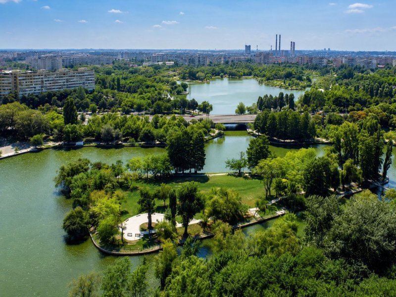
Lake Tineretului
Lake Tineretului lies in a park with a powerful urban story. The area was associated with Valea Plângerii and with difficult, degraded land, transformed through a major landscape intervention in socialist Bucharest. From a place with a poor reputation emerged one of the city’s largest green spaces.
The lake’s water has a recreational and landscape role. Its quality depends on maintenance, vegetation, cleaning, and the intense use of the park. Tineretului is an example of urban recovery: the city took a problematic piece of land and turned it into a place where runners, children, cyclists, and people with bags of sunflower seeds coexist in a relatively peaceful order.
Lake Titan
Lake Titan, in Alexandru Ioan Cuza Park, known to many Bucharest residents as IOR, is one of the strongest emotional neighborhood landmarks. The park was laid out in the second half of the 1960s, and the lake, with its islands, became the center of public life in Titan. Around it, a healthy urban routine took shape: walks, running, fishing, benches, ducks, swans, children, and sunset photographs.
Its water quality is that of a heavily used park lake, dependent on cleaning, recirculation, vegetation, and bank protection. Titan has the advantage of a community that uses it and claims it. When a lake becomes an emotional landmark, the administration receives useful pressure, even if it sometimes arrives in the form of highly creative internet comments.
The lake in Drumul Taberei Park
The lake in Drumul Taberei Park has a more recent history in its current form and has become an important landmark for Sector 6. The park underwent a major modernization project, contractually begun in 2011 and finally received in 2020, with works that also included the rehabilitation of the lake banks. In a neighborhood that already had a generous relationship with the green spaces between apartment blocks, the lake completes the logic of a broader urban breathing space.
The water has a decorative and recreational role. Its quality depends on the park’s installations, maintenance, and public behavior. In a city where green space often comes under siege, a well-maintained neighborhood lake becomes a normal luxury, precisely the kind of normality Bucharest always seems to discover with a slight delay.
The lake in Circus Park
The lake in Circus Park is one of the strangest and most delicate appearances in aquatic Bucharest. The park was laid out in Sector 2, on the former Tonola pit, and the systematization works and construction of the water installation began in 1960 and were completed in 1961. From this biography of clay, systematization, and mid-20th-century urbanism came a place with a distinct atmosphere: a park hidden between boulevards and apartment blocks, with the Metropolitan Circus nearby and an almost round, naturally fed lake that seems detached from a more patient city.
The lake’s fame comes especially from the Egyptian lotuses, one of the most surprising botanical presences in the capital. In summer, when the large leaves cover the water surface, the place gains an exotic note strong enough to make Bucharest residents forget, for a few minutes, the intersections around them. In local urban literature and accounts of the park, the idea often appears that the lake has natural springs and a surface of approximately 0.75 hectares, while the lotuses have become its fragile, spectacular, and very easily lost symbol.
This fragility is precisely what makes Lake Circus important in the guide. In recent years, the water level has visibly dropped, and the authorities have linked the problem to the damage affecting underground springs, in the context of real-estate developments with deep foundations in the area. Water quality must be read here through the lens of a very sensitive urban ecosystem, dependent on natural feeding, constant water level, habitat protection, and maintenance works carried out with care, rather than with excavator enthusiasm.
The lake in National Park / Lia Manoliu
The lake in National Park, commonly known also through its association with the Lia Manoliu area, is one of those Bucharest lakes that live in a discreet paradox: many people pass nearby, but relatively few see it as one of the city’s aquatic landmarks. The park is located in a heavily trafficked area of Sector 2, between Basarabia Boulevard, Mihai Bravu Road, and Major Ion Coravu Street, while the proximity of the National Arena has given it an urban notoriety linked mainly to sport, concerts, traffic, and crowds moving in waves.
The lake, however, has its own park biography. In recent documentation related to the modernization of National Park, the lake appears explicitly as a central element of the intervention: dredging, bank restoration, promenade arrangements, and the preservation of the island as a bird habitat.
From the point of view of water quality, the lake in National Park should be treated as a park lake under strong urban pressure. It has excellent potential as a neighborhood promenade, especially if modernization preserves the balance between access, quiet, vegetation, and habitat. Bucharest has enough spaces where people have conquered all the land; here, the birds’ island deserves to gain a few meters of silence.
Lake Văcărești, the wetland that occupied an abandoned project
Văcărești has the most spectacular urban biography on this list, with an important clarification: the term “lake” simplifies a much more complex reality. The area formed on the site of the former hydrotechnical development called “Văcărești Lake Reservoir,” abandoned in 1989, and nature did what it knows best: it entered the free space, brought reeds, birds, amphibians, small mammals, insects, aquatic plants, and a biodiversity difficult to imagine from outside.
This is how Văcărești Natural Park was born, established in 2016 and considered Romania’s first urban natural park. The term “lake” covers water pools, ponds, canals, wetlands, and reed beds. Water quality varies seasonally and depends on rainfall, feeding, evaporation, vegetation, and the urban pressure around it. Văcărești shows that the city can produce biodiversity even from an administrative failure, provided that the space receives protection, research, education, and respect.
What happened to the vanished lakes and ponds
Old Bucharest was much wetter than it seems today. It had ponds, marshes, pools, flood-prone areas, and watercourses with freer routes. Many disappeared through drainage, canalization, systematization, and urbanization. The modern city was built, to a great extent, over these slow waters, considered unhealthy or inconvenient.
Balta lui Dura Neguțătorul entered the history of Cișmigiu. The marshy land was transformed into a public garden, and the water became a park lake. The Filaret area was integrated into Carol Park. Valea Plângerii and the Cocioc area entered the history of Tineretului Park. Balta Albă remained mainly as a neighborhood name, with a memory linked to the city’s edge, epidemics, lime, and peripheral land. The Tonola pit, even though Lake Circus does enter the inventory of the 19 landmarks discussed in detail here, remains an important example of degraded land transformed into a park with water and would deserve to be included in an expanded version of the guide.
These disappearances had real reasons: hygiene, protection, urbanization, housing, infrastructure. The price paid was the loss of a natural geography that could have given the city more blue-green corridors. Bucharest gained buildable land and lost part of its memory of water. This explains why many neighborhoods still bear names that sound aquatic, even though the water has disappeared from the landscape.
The importance of Bucharest’s lakes
Bucharest’s aquatic landmarks form a parallel map of the city. They show how the capital fought floods, drained ponds, created parks, altered neighborhoods, recovered degraded land, and sometimes allowed nature to do by itself what the administration would have sent through five committees and three approvals.
A complete guide to Bucharest’s waters should become a form of urban education. Each lake deserves a clear profile, with history, management regime, water quality, bank access, routes, biodiversity, and problems. Herăstrău needs maintenance worthy of its fame. The Colentina needs coherence along the entire chain. Lake Morii needs a promenade worthy of its size. Văcărești needs serious protection. Park lakes need constant care, the same modest and efficient care that makes the difference between a tired city and a livable one.
Bucharest has more water than it seems. Its problem is not the absence of lakes, but the absence of a mature conversation about them. And this conversation begins simply: with their names correctly placed on the map, with their stories told without fantasies, and with water treated as a living part of the city, rather than as leftover space between two investments.
You may also like: Bucharest and its waters: the rivers and lakes that shaped the city