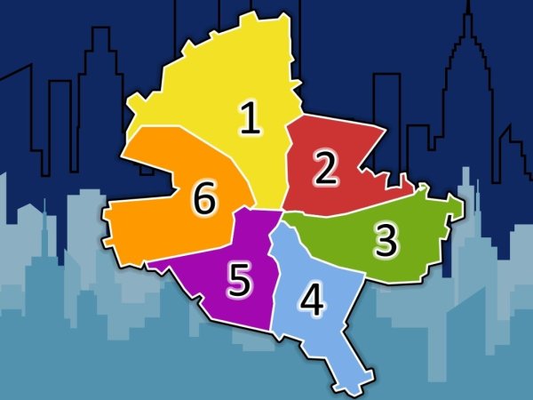
Map of Bucharest’s districts. Which neighbourhoods are included in each part of the capital?
By Raluca Ogaru
- Articles
- 30 JUL 26
Bucharest is divided into six administrative districts, but their boundaries do not always follow easily recognisable routes. Some streets, boulevards, neighbourhoods and even central squares lie close to the border between two or three local administrations, which is why the same area may be associated with different districts in everyday conversation.
Viewed on a map, the capital resembles a circle divided into six irregular sections. Each district starts close to the city centre and extends towards the boundary with Ilfov County. District 1 covers the north and north-west, District 2 the north-east, District 3 the east, District 4 the south, District 5 the south-west and District 6 the west of Bucharest.
How Bucharest’s six districts were established
The current administrative division dates back to 1979, when the eight districts that existed at the time were reorganised into six. Decree No. 284/1979 describes their boundaries through a succession of streets, railway lines, waterways and landmarks located near the edge of the city. This administrative structure remains in place today.
The legal descriptions are difficult for an ordinary reader to follow, particularly because some roads appear under the names they had during the communist period. In practice, residents usually navigate the city using well-known neighbourhoods, metro stations, squares and boulevards.
There is, however, an important difference between a district and a neighbourhood. A district is an official administrative subdivision, with its own city hall and local council. A neighbourhood is a historical, urban or commonly recognised area, but it does not have a separate administration and its boundaries are not always officially defined.
Which neighbourhoods are included in each district of Bucharest?
The list below includes the main neighbourhoods and well-known areas in each district. It should be regarded as a general guide, because some neighbourhoods extend across administrative boundaries, while certain names are used for smaller areas within a larger neighbourhood.
District 1: northern and north-western Bucharest
District 1 begins in central Bucharest and extends northwards towards Otopeni, Mogoșoaia and Băneasa Forest. It includes some of the capital’s best-known residential neighbourhoods, as well as areas around Gara de Nord and the Bucureștii Noi–Străulești corridor.
The main neighbourhoods and areas in District 1 are:
- Aviatorilor;
- Aviației;
- Băneasa;
- Bucureștii Noi;
- the part of Chitila located within Bucharest;
- Dămăroaia;
- Domenii;
- Dorobanți;
- part of Floreasca;
- Gara de Nord;
- Grivița;
- Kiseleff;
- Pajura;
- the part of Pipera located within Bucharest;
- Primăverii;
- Străulești;
- Vatra Nouă;
- Victoriei;
- a small part of Giulești.
Official District 1 documents list Aviatorilor, Aviației, Băneasa, Bucureștii Noi, Dămăroaia, Domenii, Dorobanți, Gara de Nord, Grivița, Victoriei, Pajura, Pipera, Primăverii and Chitila among its neighbourhoods.
The name “Pipera” can create confusion. Part of the office and residential area commonly known by this name is located in District 1, but Pipera itself belongs to the town of Voluntari, in Ilfov County.
District 2: north-eastern Bucharest
District 2 stretches from the central area around Moșilor and Foișorul de Foc towards Colentina, Fundeni and Pantelimon. It also includes several lakes along the Colentina River chain, including Tei, Plumbuita and Fundeni.
The main neighbourhoods and areas in District 2 are:
- Andronache;
- Baicului;
- Colentina;
- Fundeni;
- Iancului;
- Moșilor;
- Obor;
- part of Pantelimon;
- Plumbuita;
- Ștefan cel Mare;
- Tei;
- Vatra Luminoasă;
- part of Floreasca;
- the Foișorul de Foc area.
Administrative documents mainly associate District 2 with Pantelimon, Colentina, Iancului, Tei, Floreasca, Moșilor and Vatra Luminoasă. Baicului and Plumbuita are also identified by the local administration as areas within the district.
Obor is one of the easiest areas to recognise, although the name may refer to the neighbourhood, the market, the railway station or the intersection around Șoseaua Colentina and Ziduri Moși Street.
District 3: eastern Bucharest
District 3 extends from the edge of the historic centre towards Titan, Balta Albă and the road leading to the A2 motorway. It includes large residential estates, former industrial areas that have been redeveloped and an important part of central Bucharest.
The main neighbourhoods and areas are:
- Balta Albă;
- part of Centrul Civic;
- Decebal;
- Dristor;
- Dudești;
- Muncii;
- Nicolae Grigorescu;
- Ozana;
- Republica;
- Sălăjan;
- Titan;
- Trapezului;
- part of Unirii;
- Vitan;
- 1 Decembrie 1918.
Local documents mention Vitan, Dudești, Titan, Balta Albă, Centrul Civic, Dristor, Muncii and Unirii among the main areas of District 3.
Titan and Balta Albă are often used almost interchangeably, although historically and from an urban-planning perspective they do not describe exactly the same territory. Within this large area, residents also use more specific names such as Sălăjan, Ozana, Trapezului and Nicolae Grigorescu.
District 4: southern Bucharest
District 4 begins around Piața Unirii and extends southwards towards Popești-Leordeni, Berceni commune and Jilava. It is crossed by Șoseaua Giurgiului, Șoseaua Olteniței and Șoseaua Berceni.
The main neighbourhoods and areas in District 4 are:
- Apărătorii Patriei;
- Berceni;
- Brâncoveanu;
- Eroii Revoluției;
- part of Giurgiului;
- Metalurgiei;
- Olteniței;
- Piața Sudului;
- Progresul;
- Timpuri Noi;
- Tineretului;
- Văcărești.
Official sources associate District 4 with Berceni, Giurgiului, Olteniței, Tineretului, Văcărești and Timpuri Noi. Other local documents also include Apărătorii Patriei, Brâncoveanu and parts of Vitan and Giurgiului.
In everyday speech, “Berceni” is used for a very large part of southern Bucharest. Within this wider area, however, there are distinct zones such as Piața Sudului, Brâncoveanu, Nițu Vasile, Apărătorii Patriei and Metalurgiei.
District 5: south-western Bucharest
District 5 extends from central Bucharest, including Cotroceni, Izvor and the area around the Palace of Parliament, towards Rahova, Ferentari and the border with Bragadiru and Măgurele.
The main neighbourhoods and areas are:
- 13 Septembrie;
- Cotroceni;
- Dealul Spirii;
- Ferentari;
- part of Ghencea;
- Rahova;
- Sălaj;
- Sebastian;
- the historic Uranus area;
- parts of Giurgiului and Progresul.
District 5 documents identify six large neighbourhoods: Cotroceni, 13 Septembrie, Rahova, Sălaj, Ferentari and Ghencea.
Rahova is sometimes used as a general name for almost the entire western part of the district, although Sălaj, Sebastian, 13 Septembrie and Ferentari have distinct identities. Ghencea is also divided in practice between Districts 5 and 6.
District 6: western Bucharest
District 6 begins around the Cotroceni–Grozăvești area and extends towards Militari, Drumul Taberei and the exits towards Chiajna and Domnești. Its main transport corridors include Iuliu Maniu Boulevard, Virtuții Road and Drumul Taberei.
The main neighbourhoods and areas are:
- Constantin Brâncuși;
- Crângași;
- Drumul Taberei;
- part of Ghencea;
- Giulești;
- Grozăvești;
- Lujerului;
- Militari;
- Regie;
- Răzoare;
- Politehnica.
District 6 City Hall presents Drumul Taberei, Militari, Giulești and Crângași as its main neighbourhoods, while the current administrative structure also includes Constantin Brâncuși.
Militari should not be confused with the residential developments marketed under the name “Militari Residence”. Most of these are located in Chiajna commune, in Ilfov County, rather than in District 6 of Bucharest.
Why some neighbourhoods appear in two districts
Bucharest’s neighbourhoods developed during different historical periods, and their names often come from former villages, estates, trade routes, military units, factories or local landmarks. The administrative division introduced later did not always follow the historical boundaries of these communities.
For this reason, names such as Floreasca, Ghencea, Giulești, Giurgiului, Vitan, Pantelimon and Centrul Civic may be used in areas close to the boundary between two districts. Someone may say they live in Ghencea, for example, without that information alone establishing whether the address belongs to District 5 or District 6.
The confusion is even greater in central Bucharest. Piața Unirii, the Old Town, Universitate, Cotroceni and Centrul Civic are all close to administrative boundaries. Two buildings located only a short distance apart may belong to different districts.
How to find out exactly which district an address belongs to
For official documents, taxes, parking permits, school enrollment or requests submitted to the authorities, the name of the neighbourhood is not enough. The full address, including the building number, must be checked. On certain roads, one section may belong to one district while another section is administered by a neighbouring district.
The postcode can provide a useful indication. In Bucharest, postcodes generally begin with 01 for District 1, 02 for District 2, 03 for District 3, 04 for District 4, 05 for District 5 and 06 for District 6. The final verification should still be made using an official address database or an administrative map, especially in border areas.
The district map provides a clear administrative picture of Bucharest, but the neighbourhood map is more flexible. Districts have legally defined boundaries, while neighbourhoods are also shaped by the way residents describe their area, the landmarks they use and the local identity built over time.