How Bucharest evolved during the interwar period, when the population grew by 127%, the city learned to develop vertically, and new neighborhoods appeared
By Eddie
- Articles
- 22 MAY 26
The history of a city marks moments when everything seems to explode at once: people arrive in waves, houses spring up like mushrooms after rain, new streets are drawn over former garbage pits with a speed that leaves you speechless, and so on. Bucharest in the interwar period experienced exactly such a moment, an expansion so spectacular that it seems almost unreal when you read the figures. In his monumental History of Bucharest, Constantin C. Giurescu describes this transformation with the precision of a historian passionate about detail, offering us the image of a city that reinvented itself completely in only two decades.
Bucharest’s first modern demographic crisis
The year 1918 brought Bucharest something absolutely unusual by the standards of the time: a decrease in population. For the first time since 1880, the capital recorded 382,853 inhabitants, 1,305 fewer than the previous year. Giurescu notes, with his characteristic attention, that the phenomenon had a grim explanation: the war had left a devastating mark.
The figures speak for themselves: 3,931 births compared with 13,631 deaths, a deficit that says everything about the trauma of a war that had just ended. Even the influx of newcomers from the provinces and nearby villages, a constant phenomenon until then, could no longer cover the gap left by the large number of deaths. It was as if Bucharest was catching its breath after four years of nightmare.
The spectacular recovery: how the population doubled in twenty years
The recovery came quickly, almost brutally quickly. In 1919, although the relative deficit continued — 8,137 births compared with 10,307 deaths — the total population rose to 389,078, thanks to those arriving from the provinces and villages. Giurescu mentions that the growth rate stabilized at around ten thousand per year until 1927, when Bucharest reached 472,035 inhabitants. Then, in 1928, came an ingenious administrative move: twelve suburban communes were added to the capital, some of them “recent creations, from after the war,” as the historian calls them, and the figure jumped to 569,855 inhabitants.
And from here, the explosion truly began. The annual increase became “much greater,” varying between twenty and thirty thousand new souls every twelve months. The figures follow one another like a brisk dance: 599,782 in 1929, 631,288 in 1930 — the census year — 661,295 in 1931, 708,943 in 1933, 786,929 in 1936, and approximately 870,000 in 1939, when the Second World War broke out.
Giurescu himself makes the final calculation, with an almost triumphal note: in twenty-one years, the population of Bucharest had grown by 127%. It was, as the historian emphasizes, “the greatest increase recorded in the course of its history.”
The paradox of surface area: why Bucharest had four times fewer inhabitants than Paris for the same area
But now comes the interesting part, the one that casts a harsh light on the way the city was developing. While the population more than doubled, the surface area of the capital grew far more timidly. From 5,614 hectares in 1918, it reached 7,800 in 1939, only 39% more. Giurescu makes a suggestive comparison: Bucharest had, for the same surface area, a population approximately four times smaller than that of Paris.
At the same time, however, the historian explains why this discrepancy caused such damage. The lack of necessary municipal revenues meant that public works suffered badly. At the end of the two interwar decades, the peripheral neighborhoods, the mahalale, lived as if still in the nineteenth century: without electric lighting, without running water, without sewerage.
But if the surface area grew more slowly, the explanation had two components. The first: vacant land within the old perimeter was being parceled out and built upon. The second, more spectacular: buildings were growing in height. Giurescu notes that this was “the period when apartment blocks appeared, when multi-storey houses with apartments were built along all the main arteries.” Bucharest was learning to grow vertically, transforming itself from a city of houses with porches into a modern metropolis of “human hives.”
The parks of the new rich: northern Bucharest becomes a select district
The northern part of the capital became the preferred ground for luxury parceling. Giurescu describes in detail how, to the left of Kisseleff Road, toward Băneasa, the Delavrancea “park” was completed and the Domeniilor “park” was established on land belonging to the Ministry of Agriculture. And he adds an ironic observation: although intended for ministry employees, the plots ended up being given “to others” as well — meaning to those who had money, regardless of where they worked.
On the right side of the road, the situation became even clearer. Filipescu “Park” was completed, where “the wealthy of the capital built sumptuous residences,” Bonaparte Park came into being, and farther north, between Jianu Road — today Aviatorilor — and Herăstrău Lake, a third park appeared. Giurescu makes a rather caustic remark about one of its areas: although it was formed through the parceling of land belonging to the Bucharest Municipal Works — U.C.B. — it was “inaccessible, however, to the minor clerks and workers of this institution.” In short: the workers of the municipal works were building houses they could not afford.
The transformation of the pits: from shelter for Bucharest’s petty thieves to public gardens
One of the most fascinating stories Giurescu tells concerns the metamorphosis of Bucharest’s “pits.” In the place of Ouatu’s pit, named after Constantin Ouatu, a landowner, an entire neighborhood rose between Filantropia Boulevard — today 1 Mai — and Calea Griviței. The actual pit, filled in and leveled, became a public garden, around which a school and a church were built between 1928 and 1934.
The description of the houses in this neighborhood offers a perfect image of the modest interwar Bucharester: “the houses are modest, in some cases you can reach the roof with your hand,” Giurescu observes, but almost all have a small garden, with flowers, trees, and “often, a vine arbor.” Farther north, another neighborhood emerged near the former “pit” of Cutarida, the one with the brick factory. Here, “cheap housing-type houses” were also built.
Cutarida’s pit also became a public garden, fully transformed, as the historian notes, only after the Second World War, when it received facilities and arrangements for children and a stadium. “Whoever sees these two neighborhoods today cannot even imagine how they looked around 1910, when at the bottom of the pits full of weeds the caramangii and manglitorii took shelter, that is, Bucharest’s pickpockets and petty thieves.”
The neighborhoods of engineers, officers, and others: the social geography of expansion
The western part of the city brought its own social geography. Giurescu points out the “neighborhood of railway engineers” to the right of Calea Griviței, directly opposite the North Station, then the new neighborhoods around Cotroceni. One was down below, in the Dâmbovița meadow, made up of villas, “many of them belonging to officers”; the other was up above, on the edge of the plateau, on the side of the War School — today the Military Academy.
The Sf. Elefterie neighborhood was also completed, with new streets bearing the names of doctors, with villa-shaped houses “with a ground floor and upper floor, surrounded by greenery.” Giurescu makes a clear social distinction here: “all these belong to the bourgeoisie, while the workers live in poor houses, on the outskirts.” Between Ghencea Cemetery and Drumul Sării, the historian inserts a philological correction: “which for a while was wrongly called Drumul Serii.”
In the southern part, parcelings of the railway institution “Casa Muncii” appeared between the tuberculosis sanatorium and Pieptănari Street, while in the eastern part, Rădorin and Berindei Parks, Mihai Bravu Park, and, to the south, at Vatra Luminoasă, a new neighborhood of standardized housing was built by the former Social Insurance institution.
Small parcelings, when three identical houses formed an “entrance”
Giurescu also pays attention to the small parcelings that appeared on private land, comprising several houses “usually in the same style, grouped around a single street or entrance.” The frequent type: “two lateral constructions and a third at the back.” The historian cites “representative” examples on Bălcescu Boulevard, 1 Mai Boulevard, Cobălcescu Street, and Maria Rosetti Street, giving us the image of a Bucharest multiplying itself through architectural cloning.
The neighborhoods of combatants and workers: the new peripheral geography
But the most important development, Giurescu emphasizes, came at the edges of Bucharest, “beyond the city limit.” New neighborhoods were born here “either through the granting of land to the demobilized soldiers of the 1916–1919 war, or through the purchase of plots by people with modest incomes, factory workers, railway workers, tram and bus company employees, re-enlisted soldiers, and minor clerks.”
Thus emerged the neighborhoods of Dămăroaia — southeast of Bucureștii Noi — Cetatea Vodă Mircea — toward Afumați — and Apărătorii Patriei — between Oltenița Road and Berceni Road — all three with former combatants. Beyond the Floreasca pit, “starting around 1922,” a new settlement with a school took shape. On the communal pastureland of Dudești, a number of residents were granted land in 1930–1931; the neighborhood would bear the name Parcul Libertății.
Near the “Titan” cement factory and the large plants formerly known as 23 August and Republica — Giurescu writes from the perspective of the 1960s — the Balta Albă neighborhood developed, with workers from these enterprises and minor clerks. Railway workers settled in the angle between the railway lines toward Chitila and Mogoșoaia, forming the commune of Griviței, which had 5,759 inhabitants in 1930, according to the census.
The commune of Lupeasca, on the road toward Alexandria, numbered 9,805 inhabitants at the same date, being “made up exclusively of parcelings,” like Griviței. Another settlement, Progresul, came into being on Giurgiului Road, and Giurescu makes an acidic remark: “its appearance corresponds, however, only partly to its name,” the irony being almost palpable.
Expansion through rural incorporation
Beyond the Colentina bridge, where the city limit was, a new settlement called Andronache formed from 1924 onward, along the road toward Fierbinți. In parallel with these new settlements, those that had existed before 1916 also grew: Militari — with many non-commissioned officers and railway workers — Băneasa — with employees of the Regia — and Colentina, which stretched along the road toward Urziceni, with restaurants serving “fresh fish, taken from the neighboring lake.”
Giurescu summarizes the process with a formulation that shows how history repeats itself: “Little by little, the city incorporates all these surrounding settlements, just as before, over the centuries, it had incorporated the neighboring villages, one after another.” It was a constant movement of expansion through absorption, Bucharest growing like a living organism that incorporates the tissues around it.
Vertical growth, from porches to apartment blocks
The most spectacular transformation remained the growth in height. Giurescu describes with fascination the appearance of “multi-storey apartment buildings, the so-called blocks, in which the dwellings, economically calculated, are lined up like cells in a honeycomb.” The honeycomb comparison becomes less idyllic when the historian notes the moment when these “true human hives” sometimes turn into “wasps’ nests.”
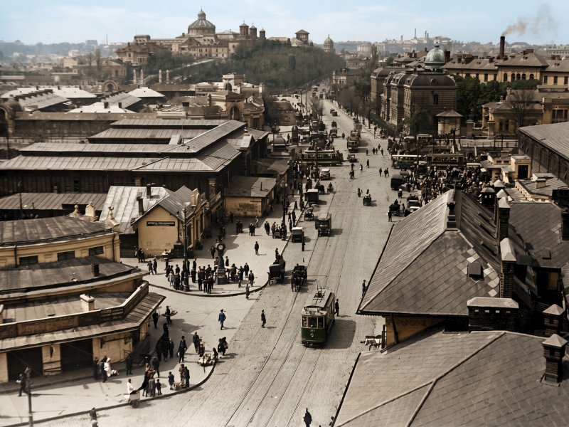
The city center, where land became “more and more expensive,” saw buildings rising along the two boulevards that cut crosswise through the city and along Calea Victoriei, then along the other major roads and, “after a while, even on less important streets.” Some blocks had seven or eight floors, such as the Carlton block, “of sad memory, destroyed by the earthquake of November 1940,” in whose place “another solid one” was built, or the Wilson block, the symmetrical blocks near the Italian Church, or those behind the Athenaeum, on Vasile Conta Street.
Giurescu closes the description with an image that perfectly synthesizes the transformation of interwar Bucharest. On Maria Rosetti Street, one could encounter “side by side, an old, patriarchal house from the beginning of the nineteenth century, with a porch in front supported by carved pillars; next to it, the wagon house of the second half of the century; and immediately after it, the apartment block or at least the small apartment block characteristic of the period between the two world wars.”
It was, in essence, the image of a city containing three different eras at the same time, three ways of understanding dwelling, three superimposed Bucharests: one romantic, with porches and carved pillars; one bourgeois, with modest wagon houses; and one modern, with tall apartment blocks announcing the metropolis of the future.
The transformation described by Constantin C. Giurescu in History of Bucharest is, ultimately, the story of a city that learned to grow both horizontally and vertically, incorporating villages and adding floors, in a desperate race to keep pace with the waves of people coming here to build their lives.
You may also like: Interwar Bucharest, a space of contrasts: the latest European fashion on muddy streets