Why Bucharest has streets named after cities. The story behind Turda Street, Timișoara Boulevard and the “maps” hidden across its neighbourhoods
By Raluca Ogaru
- Articles
- 30 JUL 26
Turda Street is located in District 1, Timișoara Boulevard crosses a large part of District 6, and in Drumul Taberei you can travel, without leaving Bucharest, along streets named after Brașov, Sibiu or Târgu Neamț. Other neighbourhoods include roads named after Arad, Bacău, Pașcani, Oradea and Suceava.
These names were not all chosen during the same period or for the same reason. Some indicated the direction of old roads leading out of Bucharest. Others were assigned in groups when new neighbourhoods were developed, making the street network easier to organise. Certain names also had a symbolic purpose, commemorating a city, region, battle or important event in Romanian history.
Bucharest’s current street register was approved by the General Council of Bucharest in 2018. The authorities also maintain records containing both the current and former names of the capital’s streets.
Streets named after cities do not all have the same history
One category consists of the old roads leading out of Bucharest. Before the city expanded, some routes indicated the destination towards which travellers were heading. Șoseaua Giurgiului continued towards Giurgiu, Șoseaua Olteniței towards Oltenița, while Podul Mogoșoaiei led towards the princely estate at Mogoșoaia.
Other geographical names did not necessarily indicate a direction, but commemorated historical events. Calea Călărașilor, for example, was previously known as Podul Vergului and received its current name in connection with the Romanian War of Independence of 1877. Names such as Plevnei, Griviței, Rahovei and Smârdan were introduced according to the same commemorative logic, recalling military campaigns and battles from 1877–1878.
A third category appeared during the capital’s major periods of expansion. When dozens of streets were created within a new residential district, the authorities often used a common theme: cities, rivers, mountains, flowers, professions, writers, composers or historical personalities.
The system also had a practical purpose. Thematic groups reduced the risk of duplicate names and gave newly planned neighbourhoods a certain degree of coherence, even if residents were not always aware of the reasoning behind them.
Where the name Turda Street comes from
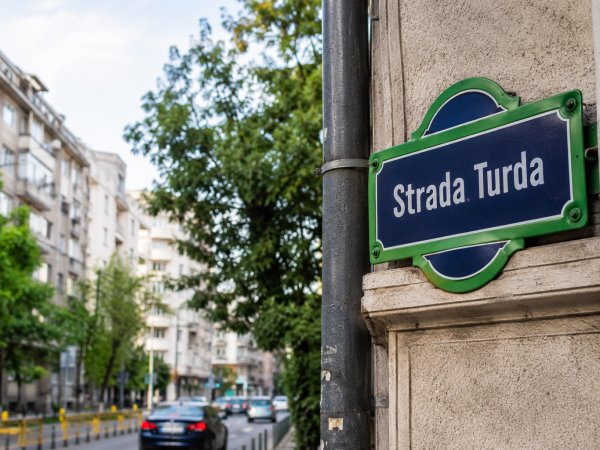
Turda Street crosses the Domenii–1 Mai area, between Ion Mihalache Boulevard and the vicinity of Grant Bridge. The name appears in Bucharest’s current official street register and is used for the road located in District 1.
Cluj Street is also nearby, while several streets in northern and north-western Bucharest bear names inspired by the geography of Transylvania. This proximity suggests a thematic system in which new streets were named after towns from the same historical region.
Publicly accessible documents confirm the official name of Turda Street, but do not provide an explanatory note establishing the precise year or reason behind its selection. It cannot therefore be stated with certainty that the name commemorates a particular event.
The most cautious explanation is that Turda belongs to the category of Romanian place names used to organise new residential areas. Such names turned the map of Bucharest into a symbolic representation of the country, incorporating towns from all of Romania’s historical regions into the capital’s street network.
Turda is therefore neither the name of a person nor an indication that the road actually leads towards the city in Cluj County. It is a geographical name that has become an urban landmark in Bucharest.
Timișoara Boulevard was once named after a communist leader
The story of Timișoara Boulevard is different. During the communist period, the road was known as Emil Bodnăraș Street, after one of the leading figures of the Romanian Communist Party.
The name appears in Decree No. 284 of 1979, which established Bucharest’s current division into six administrative districts. The document used Emil Bodnăraș Street as one of the reference points defining the boundaries of District 6.
After the fall of the communist regime, the road was renamed Timișoara. A government decision issued in January 1991 already referred to “Timișoara Street, formerly Emil Bodnăraș”, confirming that the change took place during the first wave of post-revolutionary renamings.
Timișoara was the city where the protests of December 1989 began, before the uprising spread to Bucharest. The new name can therefore be understood in the context of removing references to the former communist leadership and preserving the memory of the Romanian Revolution.
Decree-Law No. 100 of March 1990 explicitly stated that many streets and public places bore names associated with the dictatorship and introduced a new legal framework for changing them.
Timișoara Boulevard is therefore not simply one of the capital’s many roads with geographical names. It also represents the symbolic transformation of Bucharest’s map after 1989.
Drumul Taberei, a neighbourhood resembling a map of Romania
District 6 offers some of the clearest examples of streets grouped according to geographical themes. Drumul Taberei and the surrounding areas include Brașov Street, Sibiu Street, Târgu Neamț Street, Pașcani Street and Poiana Sibiului Alley.
These are complemented by names inspired by rivers and geographical features, including Valea Oltului, Valea Ialomiței, Râul Doamnei, Valea Argeșului, Ceahlăul and Peștera Scărișoara. Current administrative documents use these names to define local areas and identify addresses.
The result is a neighbourhood in which the geography of Romania has been compressed into a network of streets. Within only a few public transport stops, one can travel from Sibiu to Brașov, from Târgu Neamț to Valea Ialomiței and then to Râul Doamnei.
The names do not indicate actual routes towards those destinations. They serve an identification function and form part of a thematic composition typical of the large housing estates developed and organised during the second half of the 20th century.
Bucharest also has a neighbourhood of world capitals
The best-known example of thematic street naming is the Dorobanți–Capitale area. Here, visitors will find streets named Paris, London, Rome, Madrid, Athens, Washington, Ankara, Rabat and Bern.
Not all of them are European capitals, even though the district is frequently presented in this way. Washington is the capital of the United States, Ankara of Turkey and Rabat of Morocco. Together, however, these names create the cosmopolitan identity of the area now widely known as “Capitale”, or “The Capitals”.
Some of these streets belong to different historical residential subdivisions developed during the first decades of the 20th century. Within the Dorobanți subdivision, names such as Braziliei, Lisabona, Washington and Bruxelles were also associated with countries allied with Romania during the First World War.
The use of geographical names was therefore not always neutral. In certain cases, it expressed Bucharest’s ambition to become a European city; in others, it reflected the alliances, military victories or political values of a particular period.
Who decides what a street is called today?
Today, assigning or changing the name of a street requires a decision by the local authorities. Names referring to personalities, historical events, political developments or cultural subjects must also be reviewed by Bucharest’s Naming Commission.
The commission includes specialists in fields such as history, geography, ethnography, linguistics and art. Once approved, the name is entered into the official street register and the national electronic register of street nomenclature.
Choosing a name has important practical consequences. A change affects addresses, administrative documents, cadastral records, tax registers, street signs, maps and the databases used by public services.
A street therefore cannot be officially renamed simply by installing a new sign. An administrative procedure is required, and the new name must be formally registered.
A map of history hidden in Bucharest addresses
Turda Street and Timișoara Boulevard appear to belong to the same category because both bear the names of Romanian cities. Their histories, however, are different.
READ ALSO:
Before the sectors, Bucharest was divided into plăși. What other subdivisions did it have
Map of Bucharest’s districts. Which neighbourhoods are included in each part of the capital?
Turda most likely belongs to a geographical naming system used to organise and distinguish residential neighbourhoods. Timișoara replaced the name of a communist leader after 1989 and inevitably acquired a meaning connected to the city where the Romanian Revolution began.
Other roads preserve the memory of historic routes, battles, the union of Romanian provinces or the country’s relations with foreign states. Viewed carefully, Bucharest’s map is more than a navigation tool. It is also an archive of the ways in which each political regime and each generation tried to tell the story of the city.