Symbols of Bucharest: The Mighty Dâmbovița and Its Five Islands
- Articles
- 06 NOV 26
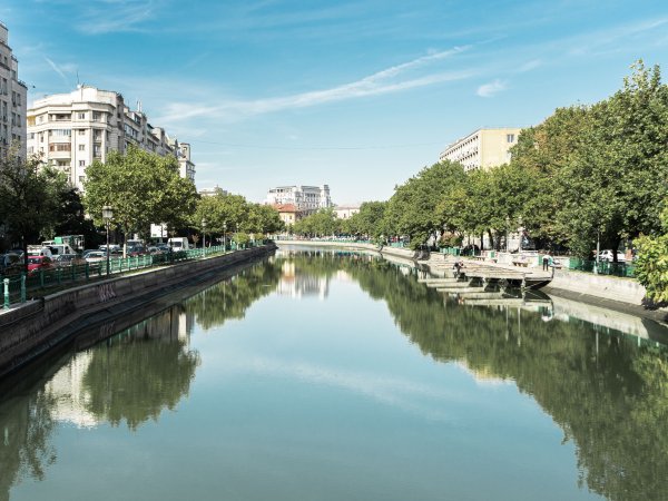
Today, the Dâmbovița River crosses Bucharest through a regulated riverbed bordered by embankments and boulevards, and its course appears so firmly established that it is difficult to imagine that the river once followed a winding path, with secondary channels, marshes, mills, fords, and islands. Yet old maps of the city preserve the image of a completely different Dâmbovița. Before the major canalization and regulation works of the 19th century, the river divided in several places and formed islands, known in Romanian as “ostroave.” Historical sources mention five such islands located at different points throughout the city. Some were small and probably temporary, while one of them, located near Radu Vodă Monastery, was more than two kilometers long and contained houses, vineyards, orchards, and small roads. The story of these five islands is, in fact, the story of another Dâmbovița and of a vanished Bucharest. Traces of this forgotten geography can still be found today in street names, old city plans, and documents describing the relationship between the city and its river.
The Dâmbovița, the river that shaped the city
For old Bucharest, the Dâmbovița was far more than a landscape feature. The river was an essential source of water, energy, and food, but it was also an obstacle that had to be crossed and, during periods of heavy rainfall, a serious threat to the city's inhabitants. Historical documents attest to the existence of mills along the Dâmbovița as early as the 16th century, while in the following centuries many mills belonged to monasteries or wealthy landowners.
The river water was used by the population and transported throughout the city by water carriers, while the power of the current drove mills that contributed to supplying the capital. At the same time, the Dâmbovița was a strongly meandering river. Its broad floodplain allowed secondary channels and islands to appear, while old maps demonstrate just how different the river's configuration was from what is seen today. Urban-planning documentation for Bucharest confirms that, before canalization, the riverbed was highly meandering, especially in the Elefterie–Schitu Măgureanu and Dudești–Șulea sectors.
The problems caused by flooding gradually led to numerous river-engineering projects. After the 1839 flood, which affected approximately one-third of the city, various solutions were proposed to control the river. However, the radical transformation of the Dâmbovița only took place toward the end of the 19th century. The canalization law was adopted in 1878, while the regulation works effectively began in 1880, between Grozăvești and Vitan. The project was completed in 1886 and permanently changed the appearance of the river and the areas through which it flowed.
The first island was located near Saint Eleftherios
The first of the five islands mentioned by historical sources was located in the Saint Eleftherios area. This is an almost unbelievable detail for modern Bucharest, because Saint Eleftherios Old Church, which today stands some distance from the river, was once situated directly on the island.
The map drawn by Sulzer in 1780 provides one of the important testimonies concerning this configuration. According to information preserved by historian George Potra and repeated in studies of old Bucharest, the island was described as a pleasant place surrounded by old trees, where Bucharest residents would often come for walks. The image is all the more fascinating because almost nothing of that landscape survives today.
The fact that a church once stood on an island in the Dâmbovița shows just how different the relationship between the city and the river was. Today, the Dâmbovița is perceived as a waterway strictly confined by urban infrastructure. More than two centuries ago, however, the river changed its course, divided into branches, and left areas of dry land between them that could become places for living or recreation.
The second island was located opposite the “Horse Garden”
The second island was much smaller and is documented in 1852. It was located opposite a place known as the “Horse Garden,” in the area where today's Vasile Pârvan Street ended. Its mention in a 19th-century document demonstrates that the disappearance of the islands did not occur simultaneously, but gradually, as the riverbed was modified.
At that time, the Dâmbovița still retained many of the characteristics of its natural course. Secondary channels, small islands, and wetlands were part of the urban landscape, even though the city was beginning to modernize. During the second half of the 19th century, however, such river formations were becoming increasingly incompatible with the development of a modern capital that was frequently confronted with flooding and sanitation problems.
The second island can therefore be regarded as one of the last testimonies of a still untamed Dâmbovița. Within just a few decades, engineering works would radically change the relationship between the river and the city, while the old channels would disappear beneath the new geometry of the riverbed.
The third island lay between the Princely Court and the Metropolitan Church
The third island is perhaps one of the most interesting from a historical perspective because it was located in an area that represented the very heart of old Bucharest. Russian maps from 1770 and Sulzer's map from 1780 indicate the existence of an island between the Metropolitan Church and the Princely Court.
Its location is also significant in connection with medieval documents. A document issued by Prince Matei Basarab in 1639 mentions a mill ford on the Dâmbovița, described in relation to the bathhouse and the island. The document confirms that the notion of an island was part of Bucharest's concrete geography long before the city's first modern maps were drawn.
This reference also illustrates the economic importance of the river. Near the Princely Court and the monasteries, the Dâmbovița was not simply a waterway, but a space of economic activity. Mills were highly important, while fords made it easier to cross the river. The island between the Metropolitan Church and the Princely Court was part of this complex geography, where water, roads, mills, and settlements intersected.
The great island near Radu Vodă was more than two kilometers long
The most spectacular of the five islands was the one located near Radu Vodă Monastery. Unlike the small islands mentioned elsewhere in the city, this was a genuine stretch of land. A map drawn in 1791 by officer Purcel indicates that it was more than two kilometers long.
The island was divided into two sections by a secondary watercourse known as a “prival.” Houses stood in its northern part, while vineyards and orchards also occupied the land. Small roads crossed it in several directions, suggesting the existence of a community and of everyday activities carried out on the island. Historical research and documents held by the Museum of the Municipality of Bucharest confirm the existence of Gârlița, the branch of the river that enclosed the large island near Radu Vodă.
The image of such a place in Bucharest two or three centuries ago is difficult to reconstruct today. In an area where busy roads and urban buildings now stand, the Dâmbovița once divided into several branches, while between them stretched a territory containing homes, orchards, vineyards, and roads. The name of Între Gârle Street has preserved the memory of this vanished geography. Its name refers to the two waterways that once enclosed the island.
The island disappeared as a result of the major regulation works carried out on the Dâmbovița. Once the riverbed was straightened and secondary channels were eliminated, the configuration of the land changed radically. During the 1880s, the Dâmbovița was deepened, its course was corrected, and its meanders, which had once occupied significant areas of the floodplain, were removed.
The last island was located near the slaughterhouse
The fifth and final island mentioned by historical sources was located, in 1852, at the edge of the city, opposite the “zalhana,” or slaughterhouse. Its location demonstrates that the islands were not concentrated solely in the historic center of Bucharest, but could also occur in peripheral areas of the city.
At that time, the Dâmbovița still had a much more natural character than it does today. Near the slaughterhouse, the river and the economic activities associated with it formed part of a peripheral urban landscape. Later, the regulation of the river and the expansion of the city caused this island, like the others, to disappear.
The transformation of the river was radical. Beginning in 1880, works carried out by French contractor Alexandre Boisguerin changed the course of the Dâmbovița between Grozăvești and Vitan. The riverbed was deepened, the banks were reinforced, and the embankments were developed. During this process, numerous meanders and secondary channels disappeared, while the old geography of the islands was absorbed by the new riverbed.
The islands disappeared, but their memory remained
The five islands of the Dâmbovița no longer exist today, but their disappearance did not completely erase their story. Historical plans, princely documents, and the research of historians have made it possible to reconstruct an urban geography that is almost impossible to imagine when looking at contemporary Bucharest.
The strongest evidence of this memory is Între Gârle Street itself. Its name continues to recall the time when the Dâmbovița had two branches enclosing an island more than two kilometers long. It is one of those rare situations in which an ordinary street name preserves the image of a vanished landscape in Bucharest.
The history of the five islands also shows how profoundly the Dâmbovița has changed. The river that today appears rigid and controlled was once a capricious watercourse that changed its path, formed islands and secondary channels, powered mills, and created spaces where people built homes and cultivated vineyards and orchards.
Ultimately, the story of the islands is the story of Bucharest's own transformation. The modernization of the capital also meant overcoming the river's old geography. In order to protect the city from floods and create the infrastructure of a modern capital, the Dâmbovița was deepened, straightened, and canalized. As a result, the islands, secondary channels, and many of the old meanders disappeared.
Yet their memory survives. It can still be found in documents, on old maps, and in the names of certain streets. The five islands remain one of the most remarkable pieces of evidence that today's Bucharest was built over a city with a completely different geography: a city in which the river did not merely cross the capital, but shaped its life, powered its mills, provided its water, and sometimes carved its own path among houses, gardens, roads, and communities.
We also recommend: The love story of the beautiful Dâmbovița and the shepherd Bucur, the most famous legend of Bucharest