Map of Bucharest’s bunkers and nuclear fallout shelters. Where they are, how to check them, and how they can be accessed
By Raluca Ogaru
- Articles
- 29 MAY 26
Bucharest has more than 1,300 civil protection shelters, popularly known as “bunkers” or “anti-atomic shelters”. However, the official term used by the authorities is “civil protection shelters”, and information about them should be checked through official sources, not only through maps or lists circulating online.
According to the official situation published by ATOP/Bucharest City Hall, prepared by ISU Bucharest-Ilfov and updated on July 5, 2025, Bucharest has 1,338 listed civil protection shelters. The official document includes the addresses, district, type of shelter — public or private — GPS coordinates, capacity and usable area. The list goes up to position 1,338, for a shelter in Sector 6, at the Polytechnic University of Bucharest, 313 Splaiul Independenței, Precis building. The document can be consulted in the official PDF with the situation of civil protection shelters in Bucharest, updated on 05.07.2025.
The topic has returned to public attention amid discussions about safety, civil protection and preparing the population for emergency situations. For residents of the capital, the practical question is simple: where is the nearest shelter, how do you check whether it appears on the official list and what do you do if the shelter is located in an apartment building, an institution or a private building?
What “anti-atomic bunkers” are officially called
The expression “anti-atomic bunkers” is frequently used in everyday language, but in official documents the term used is “civil protection shelters”. The difference is not only one of vocabulary. The official term describes spaces arranged for the protection of the population in specific situations, according to civil protection rules.
On the ATOP Bucharest page dedicated to the situation of civil protection shelters, sheltering is explained as a specific measure for protecting the population, material goods, cultural and heritage values during military hostilities and emergency situations. The same source states that civil protection shelters are specially arranged spaces, designed, built, equipped and authorized according to technical norms developed by the General Inspectorate for Emergency Situations.
The ATOP page also mentions the capacity criterion for new constructions: 1 square metre of usable area for each person. This information is important because it explains why official lists include different capacities, from several dozen people to hundreds or even more than a thousand people in some large buildings.
Where to find the official list of shelters in Bucharest
The most important source for Bucharest is the list published by ATOP/Bucharest City Hall, prepared by ISU Bucharest-Ilfov. The document updated on July 5, 2025 lists 1,338 civil protection shelters, with technical data for each entry: address, district, public or private type, GPS coordinates, capacity and usable area. This is the source behind the statement that Bucharest has more than 1,300 civil protection shelters.
At national level, the General Inspectorate for Emergency Situations publishes a centralized situation of civil protection shelters. On the IGSU page with civil protection shelters, there is a document updated on March 9, 2026, which includes information about addresses, type, coordinates, capacity and functional status.
For Bucharest and Ilfov, another useful source is the ISU Bucharest-Ilfov page dedicated to sheltering. It centralizes information for the Bucharest-Ilfov area and should be consulted when looking for data as close as possible to the local level.
The interactive map: useful for orientation, but not an official source
For those who want to see shelters more quickly on a map, there are also interactive maps created independently, based on public data. One of the best known is the civil protection shelter map created by Teoalida. It can be useful for visual orientation, especially if you want to quickly see what points appear near a certain area or address.
However, the Teoalida map is not an official IGSU, ISU Bucharest-Ilfov or PMB map. It should be presented as an unofficial tool created based on public data. The map’s own page mentions that some coordinates in the documents used may be inaccurate, meaning they may indicate the correct street, but sometimes several hundred metres away from the building or shelter listed.
For this reason, the interactive map can only be recommended as an orientation tool. To check the exact address, the priority source should be the official list published by IGSU, ISU Bucharest-Ilfov or PMB/ATOP. In a real emergency, information communicated by the authorities, the DSU app and official instructions take priority over any unofficial map.
How “anti-atomic bunkers” can be accessed
Access to civil protection shelters depends on the type of shelter and the building in which it is located. Some are public and are located in institutions, schools, kindergartens, administrative spaces or buildings managed by public authorities. Others are private and are located in the basements of apartment buildings, residential complexes, office buildings, commercial headquarters or other private buildings.
In peacetime, some shelters may be used for other purposes, while respecting technical norms. On the ATOP Bucharest page, in the excerpt from Law no. 481/2004 on civil protection, it is stated that public civil protection shelters, except for spaces arranged as command points, may be used in peacetime for other purposes, but must be cleared in emergency situations within a maximum of 24 hours, with prior notification of the operational centres within professional emergency services.
For apartment building residents, the first step is to check the official list. If the building or a nearby building appears on the list, the next step is to ask the building administrator or owners’ association where the shelter is located, whether access is marked and whether the space is kept clear. In private buildings, normal access may be controlled by the owner, administrator or security staff, but in emergency situations the instructions of the competent authorities apply.
It is important to say that people should not try to force access into a private shelter or an apartment building basement just to check it. Verification should be done through official sources, the building administrator, the owners’ association or competent institutions. In a real emergency, access and the direction of the population must follow the authorities’ instructions.
Who must maintain the shelters
Shelter maintenance is an obligation of the holders and users of these spaces, depending on the type of building and the shelter’s legal status. The ATOP Bucharest page cites Law no. 481/2004 and shows that citizens are required to participate in maintaining shelters in privately owned buildings and, if necessary, in arranging shelter spaces on the ground.
The same source states that public civil protection shelters are periodically inspected by specialized staff from professional emergency services. The holders and users of these shelters must comply with the measures established for keeping the spaces and utility installations in working order.
In practice, the problem appears especially in apartment buildings where basements have been used for years as storage rooms, improvised depots or technical areas. If a shelter is occupied with furniture, personal objects, flammable materials or improvised storage, access can become difficult. Residents can ask the administrator for information about the shelter’s condition and the obligation to keep the space accessible.
Why differences appear between lists and maps
Differences appear because official lists are administrative documents, not navigation apps. They contain addresses, coordinates, capacities and shelter type, but do not always clearly show the exact entrance, building staircase, access status or whether the space can be easily identified on site.
In addition, many shelters are located in apartment building basements or private buildings. Even if they appear on the official list, actual access may depend on the administrator, owners’ association, building owner or procedures established by the authorities. This does not mean that the list is wrong, but that there is a difference between technical records and the way a citizen can quickly identify the space.
GPS coordinates may also be approximate. In a city with large apartment blocks, multiple entrances, inner courtyards and complex addresses, a point on the map may lead nearby, but not necessarily exactly to the shelter entrance. That is why the most cautious approach is to use the map as a visual reference and then check the address in the official list.
How civil protection shelters are marked
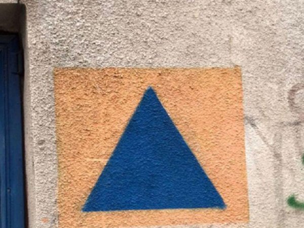
Civil protection shelters must be identified by the distinctive civil protection sign. The ATOP Bucharest page explains that it consists of a blue equilateral triangle on an orange background, used to identify civil protection services and spaces.
The marking should exist on shelter access doors and on the wall at the building entrance leading toward the shelter. In practice, however, some markings may be old, damaged, difficult to see or missing. The fact that you do not immediately see the sign does not automatically mean that there is no shelter in the building, but it is a reason to check the official list or ask the administrator.
For apartment building residents, verification is relatively simple: search for the address in the official list, check whether it appears as a private or public shelter, then ask the administrator or owners’ association for information. If there are uncertainties, local authorities or ISU Bucharest-Ilfov can be contacted.
The safest neighbourhoods in Bucharest
There is no official ranking of the “safest neighbourhoods in Bucharest” based on civil protection shelters in the documents consulted. The lists published by the authorities show addresses, districts, capacities and shelter type, but do not classify areas of the city by safety level. Therefore, it would be incorrect to say that a neighbourhood is “the safest” simply because it has more shelters.
What can be said correctly is that some areas appear to be better covered by shelters than others, especially neighbourhoods with many apartment buildings built during the period when technical basements and civil protection spaces were more often included in construction projects. The official lists include numerous shelters in high-density apartment block neighbourhoods such as Drumul Taberei, Militari, Titan, Berceni, Colentina, Bucureștii Noi, the Obor area, the Iancului area, the Tineretului area or neighbourhoods built extensively during the communist period.
However, the real safety of an area is not measured only by the number of shelters. Their condition, capacity, distance from home, access, signage, maintenance and the authorities’ instructions in case of emergency also matter. A neighbourhood with many shelters on the list is not automatically safer if the spaces are difficult to access, non-functional or insufficiently known by residents.
For a Bucharest resident, the useful question is not “which is the safest neighbourhood?”, but “which is the closest shelter to my address and what does the official list say about it?”. From this point of view, each resident should check their exact street, building or area, not only the district or neighbourhood.
How to check the closest shelter to you
The first step is to search for the address in the official list, not only on a map. If you live in Bucharest, check the documents published by IGSU, ISU Bucharest-Ilfov or PMB/ATOP. The lists contain addresses, coordinates, capacities and shelter type. If the address is very close to your building, it is worth checking with the owners’ association as well whether there is a shelter in the building.
The second step is to use the interactive map only as an orientation tool. A map can quickly show areas where shelters exist, but it does not replace the official list. If the map indicates a point nearby, check the exact address in the authorities’ documents and do not assume that the point on the map automatically indicates the exact entrance.
The third step is to follow official communications in emergency situations. The DSU app, available for phones, includes alerts and useful information regarding emergency situations, and IGSU recommends getting information from official sources. In real situations, the authorities’ instructions are more important than any list consulted beforehand.
What should not be misunderstood
The existence of a shelter in the official list does not mean that the space is automatically accessible at any time, under any conditions. Some shelters are in private buildings, others may have controlled access, and some may require clearing or preparation. Also, the fact that a shelter appears on an interactive map does not guarantee that the point on the map is perfect or that the space is functional.
Nor should the term “anti-atomic” be understood as meaning total protection in any nuclear scenario. The term is popular, but official documents refer to civil protection, sheltering and measures to protect the population. The difference in language matters because it avoids unrealistic expectations.
The safest way to get informed is to consult official sources and check the exact address. Unofficial maps are useful for orientation, but they should not be used as the only source. In emergency situations, the instructions of the authorities must be followed, not assumptions made earlier based on a map or an old list.
What to remember
Bucharest has more than 1,300 civil protection shelters, popularly known as bunkers or anti-atomic shelters. This statement is based on the official situation published by ATOP/Bucharest City Hall, prepared by ISU Bucharest-Ilfov and updated on July 5, 2025, which lists 1,338 entries across the capital.
For verification, the priority sources are IGSU, ISU Bucharest-Ilfov and PMB/ATOP. The interactive map created by Teoalida can be useful for visual orientation, but it must be presented as an unofficial tool, built on public data and with possible positioning errors.
Before drawing any conclusion, the exact address, type of shelter, access, capacity and condition matter. Correct information does not mean panic, but preparation. In a large city such as Bucharest, knowing where civil protection shelters are and which official sources should be consulted is a simple act of urban responsibility.
READ ALSO: